I’m not good at geography, but I’m going to pretend that that’s New Zealand and this is revenge for all the times NZ was left off the map.
But you actually can make out New Zealand!('s North Island.) Auckland is easy to see, and I can just make out Wellington from the preview version. When I look at the full-resolution there are enough dots scattered around to make out the full North Island, plus a couple of the bigger towns on the South Island.
Nothing that exciting. I just live in a very small community, quite a distance from any larger community, and I'm pretty sure that at the scale of that map - my community doesn't exist. If I zoom in enough, maybe there's something there, but I think it's digital compression artefacts.
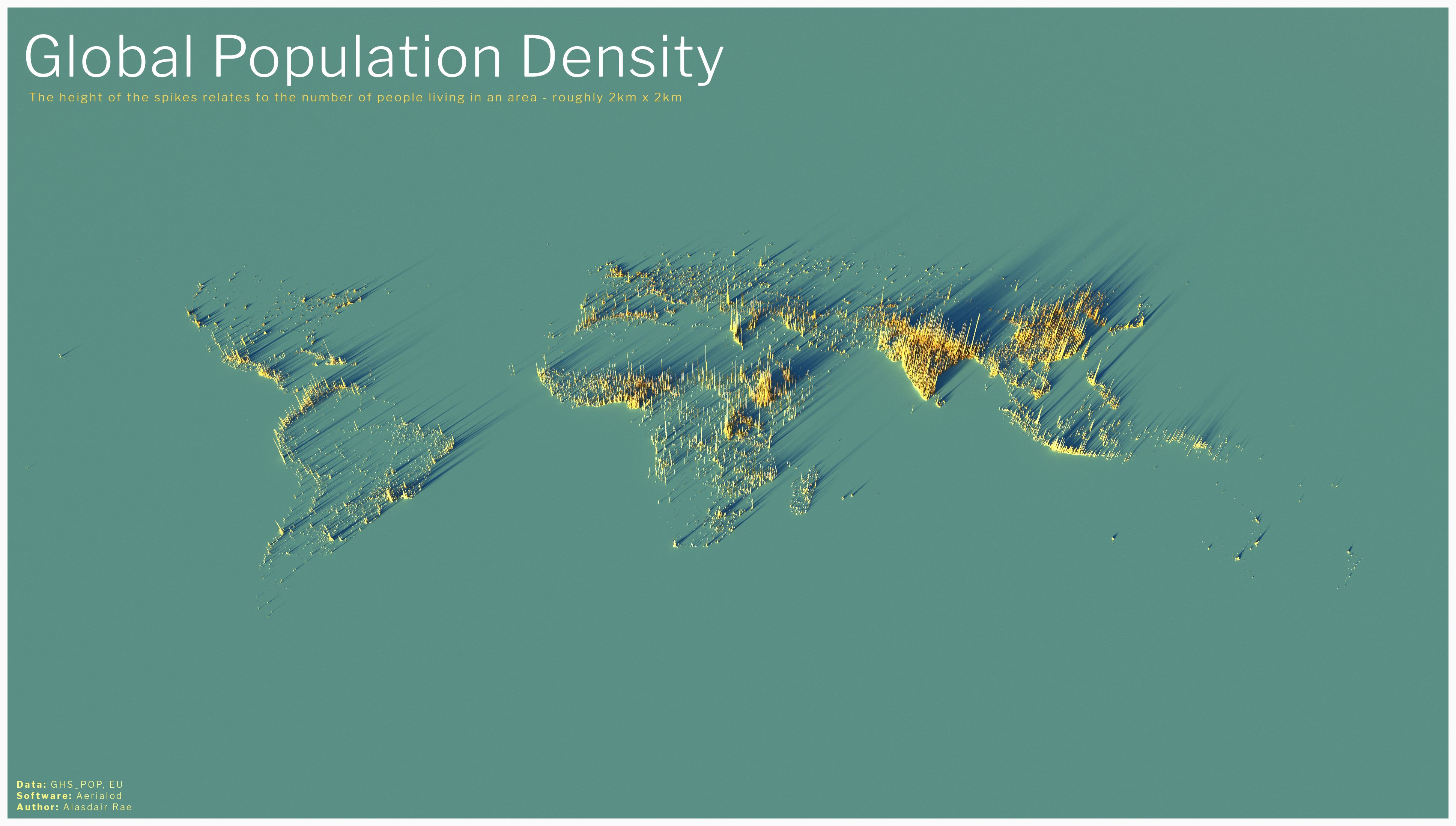
Europe looks less dense than what I expected. And north Africa is way denser than I thought. Which puts the "migrant crisis" in perspective.
Basically all countries that started having some economic growth since 1950 will have this spike effect. The countries that were already rich had a slow population transition, the other ones a fast one. The short version of that story is that in the latter child mortality went down slowly, and in the the former it was a quick proces. People take some time to adapt to this new reality, which means that for a shirt period of time 10 of 10 children will grow up to have kids of their own. After a while, the amount of children goes down to 2 or less, and growth stops. In Europe, this lade population multiply by two or three, in North Africa for example it can be up to times five or more. And in modern societies, this kind of growth tends to concentrate in cities.
What you didn't say is how empty the Sahara is. Still refugees don't just stay there. I wonder why. /s
I had no idea Port-au-Prince was so dense. It’s the ninth most densely populated city in the world and top in the Western Hemisphere.
I get your joke but isn't it there? Or is this part of Austria? It's hard to tell but I think New Zealand is there
Yet it is there. Only continent totally thrown of the edge is Antarctica. I wonder why... just asking questions, not implying any agenda
I don't think penguins are included in the population count, otherwise NZ would have another 500k population.
I'm pretty sure there's a Big Antarctica conspiracy to keep penguins off the map, hiding their army of 44m penguins.
Holy shit i had no idea Ethiopia was so crowded. it's cool how you can see population swells around the Nile and Lake Victoria too. and the Mediterranean coast of course. and I guess Nigeria is just a good place to live??
This map looks good, but feels somewhat misleading. For me, it looks like India is home to about half of the world's population.
Still, very beautiful presentation.
India has 17% of the world's population - on a scale like this image, that's not far off "about half"! It looks right to me.
Huh, I can read Canada. I call bullshit on the 2x2 thing, though. This is more like 10x10, otherwise you'd see a lot of smaller communities.
It's mostly not surprising, but laid out like that I wonder how long places out of the historical spotlight have been that populous. Ethiopia is quasi-historical enough we can be pretty sure it's long been a center, but the African Great Lakes? Who knows.
Pretty sure that if you can see Valencia and surroundings, you should be able to see Barcelona which is to its northeast, and that small central peak in the Iberian Peninsula looks to me to be close to Madrid, what is it then?
I'm on mobile, so a bit annoying to edit pictures, but having looked at it again, Barcelona and Madrid are visible.
Let's take a moment to appreciate that almost every one of those billions of people was someone doing the dirty and the rest were turkey-bastered in :3