
Is this really the best way to track bus and other routes?
I'm taking a look at traffic circles like this:
https://www.openstreetmap.org/edit#map=19/33.790043/-118.142392
The main traffic circle has been split up into 8 different segments, so that individual segments can have Relations added to them, such as the "Long Beach Transit 174" bus route. I'm new to mapping, so I don't really know what to expect, but it seems odd to split it up like that. It ends up adding noise to StreetComplete, in that I can't just say "yep, this traffic circle is asphalt", I have to go to a bunch of tiny segments and mark each one of them as asphalt.
I've also seen this for items generated from Lyft data, where a single road gets split into tiny segments so that one part can be marked as "no u-turn" or "no left turn". StreetComplete wants me to mark each tiny segment individually.
What value should I use for traffic_signals=*?
I'm looking to tag a simple 4 way stop with typical US red/yellow/green traffic signals. I was wondering what the difference between signal and traffic_lights is in iD, and the wiki page just says this about traffic_lights:
A typical traffic signal. This value was the second most common value as of 2021-09-15 despite being undocumented until that point.
Looking at the talk page there, it links to this post, where an iD dev seems rather annoyed at the wiki:
I took a look at https://wiki.openstreetmap.org/wiki/Key:traffic_signals and now I'm furious.
Forget it.
There is no way I'm going to support traffic_signals=yes for pedestrian signals, after the wiki folks aren't even ok with iD using traffic_signals=signal for a normal traffic signal - a tagging that was accepted just not very widespread before iD started doing it.
The OSM Wiki needs to end. Seriously. It's ruining this project.
I'm using iD, so should I just leave it as the default signals and leave the fighting up to the devs? As an aside, does anyone know why there seems to be so much animosity there? Kind of surprising TBH
What is the best way to mark an inactive bus stop?
I've encountered a bus stop that still exists, but has a sign from the city saying that no busses stop there. There's the disused tag on the wiki which seems relevant, but I'm not sure how to tag it exactly. There's lots of tags like ref, route_ref, operator:wikidata and so on. Should all of those tags get prefixed with disused:?
was ist denn heute mit #Openstreetmap los? Läd das nur bei mir nicht bzw. nicht richtig?
was ist denn heute mit #Openstreetmap los? Läd das nur bei mir nicht bzw. nicht richtig?
What's going on with #Openstreetmap today? Is it just me that it's not loading or not loading properly?
#osm @openstreetmap@en.osm.town @openstreetmap@lemmy.ml @osm_tech
Can I assume orthoimagery is the best for tracing buildings?
I'm trying to correct local buildings on OSM. I've noticed that some of the buildings were traced before according to one set of satellite images, but are off according to others. One of the options for a background while editing that I've got is called orthoimagery. Can I assume that that is the best set of satellite images for tracing buildings from?
Magic Earth and spurious closures
I've tried Magic Earth a handful of times, but each time I dumped it because it marked a street as closed or wrong-way, creating a circuitous detour. There's no such issue in OSM; it simply hallucinated something.
I was testing it so I knew where I was going, but I'm reluctant to rely on it when I really need nav. Have I been supremely unlucky?
Google removed Organic Maps from the Play Store
Organic Maps (@organicmaps@fosstodon.org)
https://fosstodon.org/@organicmaps/112976308191001762
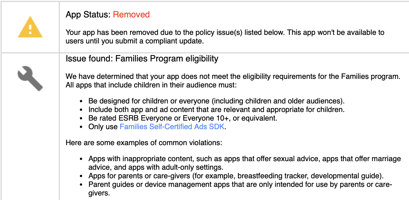
Attached: 1 image Last night Organic Maps was removed from the Play Store without any warnings or additional details due to "not meeting the requirements for the Family Program". Compared to Google Maps and other maps apps rated for 3+ age, there are no ads or in-app purchases in Organic Maps. We have asked for an appeal. As a temporary workaround for the Google Play issue, you can install the new upcoming Google Play update from this link: https://cdn.organicmaps.app/apk/OrganicMaps-24081605-GooglePlay.apk
Guide for indoor shopping mall?
I've decided to tackle an indoor shopping mall near me. This will be shops within a larger structure, walking paths, and other features. Is there a guide anywhere for doing this correctly?
Street Complete Notes - Am I doing this right?
I just started "playing" Street Complete and noticed there was no way to add stuff like new bemches amd trash cans to the map. I found the "create note" feature and started using that for this purpose.
Before I continue like thisI just wamted to check with you guys and see; Am I doing this right?
https://www.openstreetmap.org/user/Hannes%20Knutsson/notes
I made some note about a new trash can, some new bench and some new stairs.
Happy Birthday OpenStreetMap – Celebrating 20 Years
Happy Birthday OpenStreetMap – Celebrating 20 Years
https://birthday20.openstreetmap.org/