What's up with Overture Maps?
When I read about Overture Maps like a year or 2 ago, it seemed to me that basically they were going to create a whole new thing from scratch.
Let's be honest, with enough resources, it's easy to see that they could pull off some kind of OpenStreetMap 2.0, where all the issues from OSM are modernised and cleaned up.
What's really going on? Are we getting something soon from these people? What's the relationship with them?
On their website, they say "coming this fall". Are you excited? Scared? What should I think?
StreetComplete vs Organic Maps
Just a super quick question about helping to update the map locations.
Between StreetComplete and Organic Maps, which is faster for submitting recommended changes to the OSM team in regards to things like business hours, etc...
Preferred way to map landuse=residential?
I've encountered some conflicting usages of Tag:landuse=residential. Some areas are very specific, and broken down into individual blocks, while some areas cover multiple blocks. Here's an example of both styles adjacent to each other:
https://www.openstreetmap.org/way/653823458
https://www.openstreetmap.org/way/652122607
The wiki doesn't really say much on the topic. Does anyone have opinions/rules of thumb on how to tag them exactly? It seems like all adjacent areas not separated by major highways should be joined together?
I've encountered some residential areas that are broken down into mapping each block, and literally follow the curb, rounded corners and all. That seems too specific?
How should sidewalk crossings be mapped exactly?
I'm looking at Tag:crossing=marked, and it's a little vague. It says:
Set a node on the highway where the transition is and add highway=crossing + crossing=marked.
If the crossing is also mapped as a way, tag it as highway=footway footway=crossing crossing=marked or highway=cycleway cycleway=crossing crossing=marked as appropriate.
Doesn't that violate the principle of One feature, one OSM element? For example, here's a crossing from where overpass-turbo defaults to showing:
https://www.openstreetmap.org/node/7780814396
https://www.openstreetmap.org/way/833493479
You've got a way with these tags:
crossing=marked
crossing:markings=yes
footway=crossing
highway=footway
surface=asphalt
And the intersection node with the street it's crossing has these tags:
crossing=marked
crossing:markings=yes
highway=crossing
tactile_paving=no
Shouldn't that be one or the other? It makes sense to me to represent the crossing as a way with all the tags, and leave the intersection untagged. I noticed though that StreetComplete doesn't really like that, and will give you quests to add tags to the intersection node even if the way is properly tagged.
weeklyOSM 738
weeklyOSM 738
https://weeklyosm.eu/archives/17493
05/09/2024-11/09/2024 Data structure, graph theory, control element but also OSM! [1] | © xkcd About us Bastian Greshake-Tzovaras has started using weeklyOSM to practice their Spanish. darkonus mar…

Large-Scale Generation of Transit Maps from OpenStreetMap Data
Just a moment...
https://www.tandfonline.com/doi/full/10.1080/00087041.2024.2325761
I'm always surprised how poor legibility the most used digital map has


One shows only a few shops, often the ones that pay the most, the other shows the true number of different places in the area.
Is there any documentation on mapping individual small plants like flowers or cacti?
@openstreetmap Is there any documentation on mapping individual small plants like flowers or cacti?
I'd like to start mapping botanical gardens but cannot find any information on this.
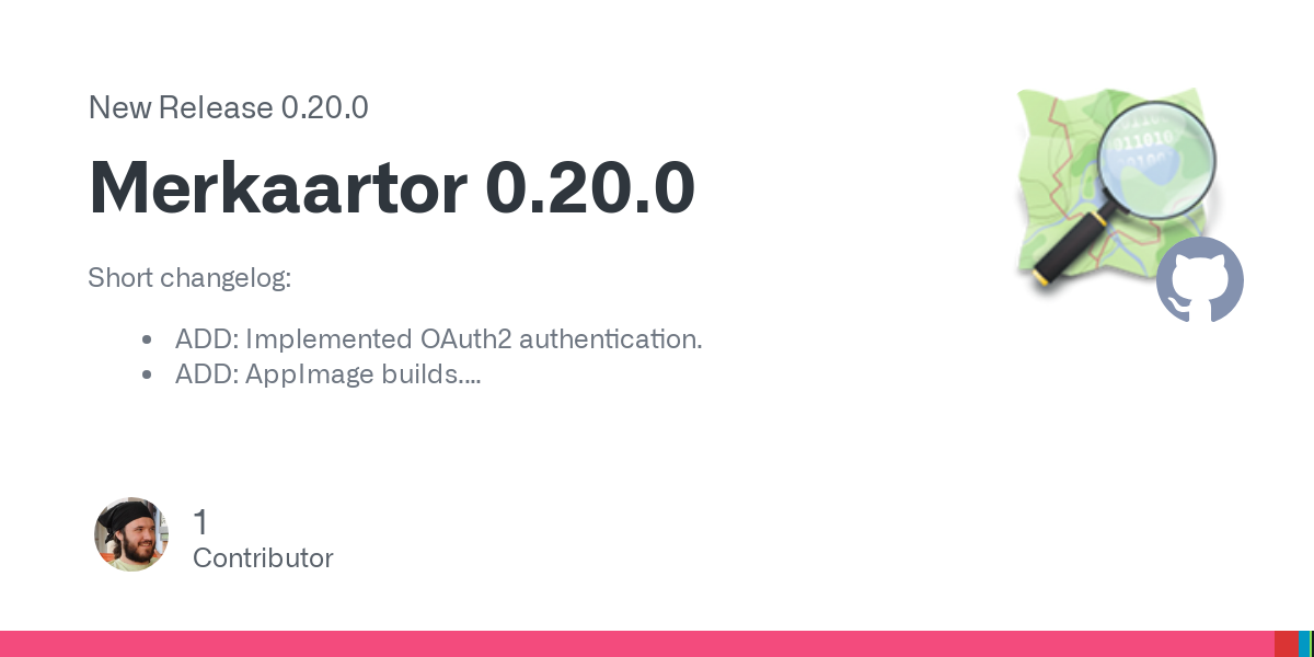
Release of Merkaartor 0.20.0 (OSM editor for PCs)
Release Merkaartor 0.20.0 · openstreetmap/merkaartor
https://github.com/openstreetmap/merkaartor/releases/tag/0.20.0
Short changelog: ADD: Implemented OAuth2 authentication. ADD: AppImage builds. FIX: Fixed CI builds. FIX: libproxy and libgps external library handling by build system. FIX: CMake unity builds. FI...